


What is Landscape Characterisation?
Landscape Characterization in DesirMED?
As you know, there is no simplistic terminologies in science to properly define and or characterise our complex adaptive landscapes. The European Landscape Convention (ELC; Council of Europe, 2000) delegates the responsibility to each participating country to identify and assess the landscapes within their territories, evaluate the factors influencing them, and develop appropriate management, planning, and protection strategies. Given the ever-evolving nature of landscapes, their classification should be purpose-driven. Regardless of the chosen method, any system for spatial landscape characterization inherently simplifies the vast complexity of landscapes into manageable spatial units, facilitating communication in both management and research (Hazeu et al., 2011). Landscape characterization is a fundamental process in spatial planning, ecosystem service assessment, and sustainable land management (Simensen et al., 2018). Defined within the framework of the European Landscape Convention (ELC), landscape characterization aims to systematically assess landscapes based on their biophysical, socio-economic, and governance attributes.
Even more critically important component of this is:
However, as Antrop & Van Eetvelde (2017) argue, there is no single universally accepted method for landscape classification. Instead, numerous methodologies have emerged, reflecting different disciplinary perspectives, spatial scales, and analytical approaches. Historically, landscape studies have evolved along three primary dimensions:
- Natural Science Perspective: Treats landscapes as tangible, ecological entities, focusing on biophysical characteristics, spatial patterns, and ecological functionality (Bastian, 2008; Mücher et al., 2010).
- Social Construct Perspective: Emphasizes the human and cultural perception of landscapes, recognizing landscapes as dynamic, evolving socio-cultural spaces (Cosgrove, 2008; Plieninger et al., 2015).
- Aesthetic and Perceptual Perspective: Rooted in arts and humanities, this approach views landscape characterization as an interpretative process shaped by human experience and cultural values (Swanwick, 2002; Van Eetvelde & Antrop, 2009).
Landscape Characterization: A Multidimensional Science
According to Groom (2005), landscape characterization methodologies vary significantly across European countries, reflecting differences in spatial typologies, land-use policy frameworks, and classification granularity. A synthesis of existing frameworks reveals six key dimensions for landscape characterization:
- Biophysical Attributes: Landform, hydrology, soil composition, vegetation, and climatic zones.
- Landscape Ecology: Habitat connectivity, biodiversity, and ecosystem structure.
- Socio-Economic Aspects: Land use, human settlements, infrastructure, and economic activity.
- Historical Landscapes: Archaeological and heritage sites influencing land-use dynamics.
- Human-Aesthetic Perception: Scenic values, cultural identity, and landscape visual appreciation.
- Policy and Governance: Legislative frameworks, conservation policies, and stakeholder engagement.
The increasing complexity of **landscape characterization** has been further influenced by the **advancement of geospatial technologies and statistical methodologies**. Since the 1990s, there has been an exponential rise in scientific research on **spatial landscape classification**, with approaches increasingly shifting toward **data-driven, observer-independent models** (Antrop & Van Eetvelde, 2017).
The Complexity of Landscape Characterization
Due to the multidisciplinary nature of landscape research, methodologies vary significantly across geography, ecology, landscape architecture, and social sciences. A review of 54 contemporary approaches identified three dominant strategies:
- Holistic Landscape Character Assessment (LCA): Emphasizes visual perception and socio-cultural aspects, commonly used in policy-driven projects (Swanwick, 2002).
- Land Use-Based Characterization: Relies on predefined geo-ecological and anthropogenic variables (Wascher, 2005; Mücher et al., 2010).
- Biophysical-Based Characterization: Uses remote sensing, GIS, and statistical models to classify landscapes based on physical properties (Brabyn, 2009; Erikstad et al., 2015).
These varying approaches underscore the importance of **fit-for-purpose methodologies**, especially in the context of NbS implementation, where both biophysical constraints and governance structures must be integrated.
Challenges in Landscape Characterization for DesirMED WP4.1
For DesirMED WP4.1, we think landscape characterization must go beyond conventional classifications and adopt a pragmatic, fit-for-purpose approach that is scalable across diverse Mediterranean landscapes. Key challenges include:
- Observer Dependence: Many classification methods still rely on subjective interpretation, requiring standardization (Alcántara Manzanares & Muñoz Álvarez, 2015).
- Cross-Scale Variability: Landscape features vary across spatial scales, making it difficult to integrate micro- and macro-scale assessments.
- Data Gaps: Inconsistencies in land cover datasets and lack of high-resolution data hinder robust spatial classification (Mücher et al., 2010).
- Interdisciplinary Integration: Harmonizing biophysical, socio-economic, and governance data remains a challenge for holistic landscape analysis (Van Eetvelde & Antrop, 2009).
These issues suggest that for DesirMED WP4.1, an **integrated approach** is required—one that combines biophysical data, socio-economic insights, and participatory methodologies.
Specifically, **landscape archetypes** will be created using available spatial data, reclassified according to biophysical, social, and governance dimensions. This structured **landscape typology** will serve as a **decision-support tool** for climate resilience planning.
To ensure that **landscape characterization** serves as a foundation for **Nature-Based Solutions (NbS) upscaling**, we propose a structured classification framework comprising three key dimensions: Biophysical, Socio-Economic, and Governance Domains. This multi-dimensional approach aligns with established methodologies in Simensen et al. (2018), Wascher (2005), and Plieninger et al. (2015).
1. Biophysical Domain
The **biophysical dimension** encompasses landscape structures and ecological systems that influence the spatial variability of land cover. Existing methodologies from European Landscape Convention (ELC) and Erikstad et al. (2015) highlight the need to incorporate physiographic, hydrological, and biodiversity attributes.
- Landforms: Elevation, slope, and geomorphology (Bastian, 2000).
- Hydrology: Rivers, wetlands, groundwater recharge areas (Hazeu et al., 2011).
- Soil and Geology: Soil types, permeability, erosion sensitivity (Chuman & Romportl, 2010).
- Vegetation and Land Cover: Forest types, agricultural landscapes, natural habitats (Meeus, 1995; Mücher et al., 2010).
- Climate and Bioclimatic Zones: Temperature and precipitation variability affecting landscape typology (Fňukalová & Romportl, 2014).
2. Socio-Economic Domain
Socio-economic factors play a pivotal role in shaping landscape evolution. While some methodologies emphasize **land use and economic activity**, others integrate **perceptual and cultural dimensions** (Swanwick, 2002).
- Land Use and Economic Activity: Urbanization, agriculture, tourism, and industry (Pinto-Correia et al., 2003).
- Infrastructure and Accessibility: Road networks, energy infrastructure, connectivity (Warnock & Griffiths, 2014).
- Demographics and Settlements: Population density, rural vs. urban landscapes (Xie et al., 2004).
- Cultural and Historical Landscapes: Heritage sites, traditional land management systems (Raymond et al., 2015).
- Ecosystem Services and Human Well-being: Recreation, aesthetic value, provisioning services (Plieninger et al., 2016).
3. Governance Domain
Effective landscape management depends on **policy frameworks, institutional arrangements, and participatory governance**. The **European Landscape Convention (ELC)** advocates for a governance-driven approach to **integrated landscape assessment** (Council of Europe, 2000).
- Policy and Regulatory Frameworks: National and EU directives on landscape protection (Mücher et al., 2003).
- Ownership and Land Tenure: Public vs. private land governance structures (Bunce et al., 1996).
- Environmental Protection and Conservation: Protected areas, restoration programs, NbS planning (Nogué et al., 2016).
- Stakeholder Involvement: Participatory governance, local community engagement (Van Eetvelde & Antrop, 2009).
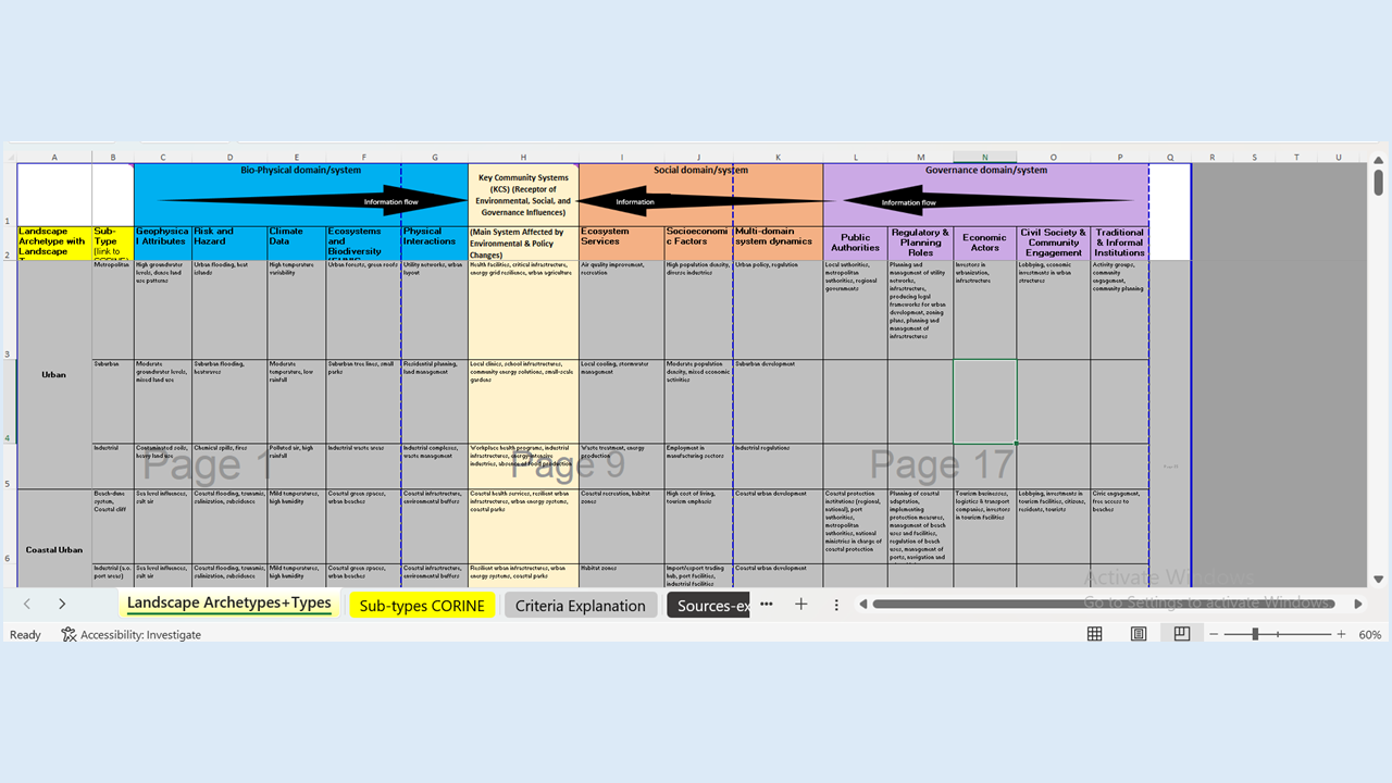
Below, you can see a screenshot of how we percieved landscape charcaterisation
4. Is the proposed approach fit for DesirMED?
The multidimensional framework provides an **integrated characterization of landscapes**, ensuring that NbS interventions are:
- Scientifically Grounded: Aligns with spatial classification principles used in global landscape studies (Simensen et al., 2018).
- Operationally Scalable: Supports NbS upscaling and cross-boundary governance applications (Erikstad et al., 2015).
- Policy-Relevant: Integrates EU policies for climate resilience and biodiversity conservation (Council of Europe, 2000).
The adoption of this framework within **Task 4.1** ensures that landscape characterization is not only **a scientific exercise** but also **a strategic tool for decision-making**, shaping sustainable landscape management across Mediterranean regions.
How Should the Final Product Look?
While the draft product concept provides a structured approach, we acknowledge that this is not set in stone. The methodology must evolve as we integrate expert input and stakeholder feedback. To ensure practical usability, we are exploring different final product formats, including:
- A Structured Overarching Table – A matrix summarizing key landscape archetypes, their risks, ecosystem services, and NbS opportunities for decision-makers to guide portfolio development and upscaling strategies. We expect this output to be landscape-specific and not general/generic
- An Interactive Media Documentation – A more descriptive and qualitative approach, combining maps, narratives, and stakeholder feedback to create a visually rich and decision-supporting product. We also expect this to be specific per case area
We invite discussions on the approach and the final product. Could this methodology enhance our ability to assess and manage landscapes more effectively? How might we refine it further to maximize its impact on NbS portfolio development and upscaling?
For further reading: